
Maulin Winter
- County:
- Wicklow
- Date:
- Saturday 9th March, 2019
- Time:
- 11:00
- Climb (m):
- 477
- Distance (km):
- 8.80
- Event Difficulty:
- 7 (2,3,2) - Moderate Terrain, >500M ascent, 6Km - 10Km
- Race Marking:
-
 -
Route fully marked
-
Route fully marked - GPS Allowed:
- Yes
- Leagues:
- Leinster Spring League
- Route Description:
Maulin 2019 – New Route - See map for confirmed route.
Route map for MAULIN 2019 by John Bell on plotaroute.com
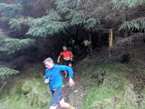
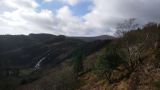
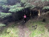
From the car park barrier continue along the forest road west for about 400m. (*marshal 1) Turn left onto a MTB track up through the forest. Continue up the MTB track for 800m crossing 3 forest roads. It gets nice and steep towards the top. (marshal 2) Turn left onto the forest road and continue southeast for 500m before joining a single track path, turn left and continue southeast for 1km where you join the Wicklow Way near the waterfall viewing point. Turn right along the Wicklow Way and continue for about 1km until you come out of the forest over a fence / stone wall onto the open mountain. Turn right onto the path leading up Maulin (off the WW and away from the Dargle River). Continue along the main path to the top of Maulin. (marshal 3) From the cairn continue west and then veer slightly right following down along the wall until the path switches back right to the northeast. Continue northeast past the gate at the top of the grassy bank (we are not going down this this year) and continue northeast down the zig-zag path through the forest. (marshal 3 after finishing at 2) At the bottom of the zig-zags turn left onto the forest road downhill for 250m then turn sharp right. (marshal 5) After another 250m turn left onto a narrowride / firebreak and continue downhill for 200m. Then turn right onto a forest road (watch out for low branches). Follow the forest road east for 500m until you reach a cross roads. Continue straight through the cross roads in a south-easterly direction for about 250m where you re-join the mtb track that you came up. Turn left and down the mtb track and back the way you came to the finish. *possible marshal positions – subject to numbers of volunteers & weather
Juniors, aged 16-19 can run the full course (i.e. there is no separate Junior course).
Map Link
Volunteers (Non-Running)
You need to have done 2 non-running volunteer roles in a calendar year to qualify for end of year prize
Volunteers (Running)
Check with race director if they have a need for people volunteering and running. Race directors need a minimum number of people available throughout the race to make the race work so non-running volunteers are preferable. While it can be helpful, volunteering in a volunteer and race capacity does not count towards qualifying for end of year prize
Carpool
| Driver Name | Location | Passing Through | Departure | Seats Available | Seats Accepted |
|---|---|---|---|---|---|
| Grainne O'Brien | Blessington | Manor Kilbride, Sally Gap | 09:15:00 | 3 | 0 |
| Stuart Scott | Ballinteer | Stepaside, Enniskerry | 09:30:00 | 3 | 2 |
| Joseph Boyle | Raheny | Killester, Clontarf, East wall, Eaat link/O2, Irishtown, Sandymount, Booterstown, Stillorgan and out on N11/M11. Will deviate within reason to Dart or Luas locations. | 09:00:00 | 2 | 2 |