
Nav challenge 2 - Croghan Mountain
Authors
Maike Jürgens
03 September, 2014
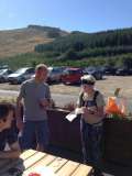
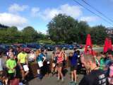
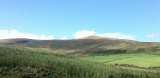
NC 2 or Fairytale forestsThis week’s nav challenge took place on a route designed by Mick Hanney around Croghan Mountain. After a week or so of rain, conditions were beautiful (or well sunny – it is questionable whether that are perfect running conditions but I am not going to complain about sunshine). I was very happy to use my new kids sun cream (very waterproof, so should be sweat proof, turned out it actually was) and Eoin pointed out I looked like a ghost with the cream on – that stuff was so viscous you could hardly distribute it on your skin. Around 11, the crowd gathered to listen to the last minute instructions by Gavan and Mick (do NOT look at the maps yet, there are more trails out there than are marked on the map, visit controls in any order you like). Off we went. I had to decide to take it easy with the Stone Cross to Lug the following week in mind. So I jogged off, trying to plan my route. And could not make up my mind in which order to visit the controls (looking at the map now it is still surprising how many things on the map I don’t see during the race). Also, I figured today was the day for adventures and off trail, unorthodox decisions. Pretty much everyone went to control 161 first, it was sort of on the way anyway. A bit further on was a trail junction at which people split up and you had to decide whether to do some sort of clockwise (control 162 next) or anti-clockwise (control 163 next) circuit. Looking at the results and from who I met along the way it appears that the clockwise option was faster for some reason. Anyway, I went to control 163 next and then over to 168, some sort of off-course control. Pondering for a minute or so to cut across from this control I figured there were too many fences to climb so I went back up the hill and then turned right downhill for a while. So far so good. My idea was to cut across the forest for a short stretch (it looked runnable for someone my height) and then go up the hill to control 166. So I went off the trail, across the river (was this an animal trail or had someone else tried this? The grass certainly looked like something had been there before me) and into the forest. I found an old riverbed that was mostly runnable and eventually saw a trail. Nice one. Unfortunately I ended up with a lot of forest in between my back and my backpack. The constant niggle started and wouldn’t stop till I finished. First mistake of the day coming up: the trail I now aimed for was a fence (talk about looking at the map carefully) and my open mountain route to control 166 was full of goarse. So change of plan. Go along the fence (again, sort of walkable for my height, thankfully) and find control 164 along the way. A few climbs across the wall at times and I was on a trail that wasn’t on the map but got me to control 164 (took me ages to see it), then up the hill to control 166 and over to 167. Along the way, I tried to check out the forest to see if I could cut across somewhere to control 165. So jogging along, I kept looking right, my brain saying NOOOO because the forest was so thick and my adventourous me thinking “why not?â€. Miraculously, a trail appeared (one of the ones that weren’t on the map) and I figured it sort of went the right direction so off I went. It was fine for a good while until it stopped. But there was a river so why not walk through the river again? That little bit of forest and goarse surely isn’t a problem. Shortly after I was sick of it. And a forest break to my right appeared. It was full of ferns (remember last week …) but it got me right to the junction that would get me to control 165. Now where is that control? I ran in a circle to find it. Now find your way to control 162 and then home. Easy peasy. Or not. At this stage, it was pretty warm, my brain was tired and the number of trails I saw around me and on the map never seemed to match up. It took ages to decide where to go at every junctions and I certainly took a few wrong turns and had to turn around. Eventually, I could see the path junction at which control 162 was – phew. So I sort of ran towards it and then the trail stopped. It seemed like it might go on on the other side of the river (mud almost up to my knees) but nope. The grass was as high as me, littered with blackberry bushes and goarse but I just went for it. Eventually, I made it to the control and went back up the hill. Apparently, I hadn’t had enough yet of the disastrous time-consuming cross-forest adventures as I went off the trail onto the field towards – exactly, the forest. There was a trail marked on the map and I thought I found it but after climbing over about 10 fallen trees (remember your childhood ☺ ) I figured I was safer going onto the trail we followed at the start. And finally I was back at the finish. A lot later than planned (oops) but still in good spirits. Thanks (especially Gavan, Mick, Daniela, Eoin) to everyone for staying out until I got back.
Lessons learned from this Nav challenge: forests are great but not necessarily suitable shortcuts. Especially if you don’t know the area well it might be better to stick to trails and do an extra km or so. And also, maybe read ALL notes on the map (so you can tell apart fences from trails … ☺ )
Navigation Challenge 2
01 September, 2014 - James H Cahill
The second navigation challenge was scheduled for Croghan Mountain. An area of the country with which I was unfamiliar and a mountain name I had never heard.I needed to redeem my performance in Navigation Challenge 1, to which I had added the additional challenge of an extra 3 km of fireroad in entirely the wrong direction. An additonal 3km is painful, but in the wrong direction is particularly so.
I car pooled down with John Condon as John wanted to take an early start. Given my efforts the previous week an early start for me seemed best for all concerned.
Arriving at 9:20 we were in good time with Gavan and Brendan arriving just ahead of us and Mick Hanney already on site. John and I lined up to take our early start at about 9:50, with James Curran taking an early start on the short course just in front of us.
The long course consisted the 5 short course controls and an additional 3 more distant long course controls to be visited in any order.
As we headed up the road towards the trail head entrance into the woods and mountain, I decided on a clockwise circuit of the most Northerly and most distant controls (162, 165, 167, 166, 164) and then a clockwise circuit of the North Easterly controls (168, 163, 161) and then home.
John and James had decided to head straight to the closest control (161) and so we parted company early on, as I took the first fireroad on the left shortly after the trail head. Marked as a small path it was actually quite a large path, but it had been made smaller by the felling which had recently taken place. Despite the branches, trees and mud I made it to the fenceline at the end of the path relatively unscathed. Up the fenceline over some more fallen trees and I joined the larger Forest Road. Running with forest on my right and open ground on my left, I decided the open ground looked very runnable and I could cut off the corner to join the path which descended to 162. The initial 200m of the plan worked beautifully until I reached some very boggy (knee deep) ground, multiple rusty wire fences and then fell in some brambles trying to cross the river to path. Bloody but unbowed I reached the path and followed its meanderings to 162.
Following the path further to a left turn brought me to a straight ascent up a rocky steep path climb which would lead me (I thought) to a choice of short cutting across some open ground or following the forest path on a more circuitous route. In fact the open ground short cut wasn’t required as an unmapped forest path brought me to join the forest road I was seeking.
Unfortunately unmarked paths tend to cause confusion in my one track mind and this required a stop and reorientation to be sure I was in the right area. A few minutes of head scratching convinced me I was correct and I proceeded to a more complex junction of tracks at which I saw James Curran descending from what I assumed to be the area of control 164 above. A sharp left down a very steep descent brought me to the well described trail underpass where the trail had been worn deep by descending water and there as mapped was control 165. Down to a sharp corner and then the ascent to rejoin the fireroad. A nice downhill run on the fireroad felt good, but I knew what goes down must go back up, so there would be a price to pay.
At the end of the wider part of the fireroad a tree blocked my path, and skirting around it I saw a small piece of tape on the other side. Mick Hanney had mentioned in his pre race briefing that he had placed some tape in various areas to show he had been there. Given that the tape was on the other side of the fallen tree, this did give me an indication that I might be running the course backwards to Mick’s original thoughts.
I now had a choice to either cut through the forestry or follow the more circuitous ascent to join the fenceline running to the summit of Croghan Mountain.
As I ran the uphill forestry trail, the forest didn’t seen navigable and so trail it would be. A lengthy ascent brought me to the point at which the trail met the fenceline and control 167. A trudge up the fenceline followed. This proved to be steep and tiring and about ½ way up I met John Condon descending, who announced that he wouldn’t like to be going up this climb as he descended happily past me. Following the fenceline brought be to the right angle fence meeting the fenceline which ran to Croghan Summit which was now clearly visible.
Although muddy in spots it was very runnable to the last climb to Croghan summit where, whilst tagging in, I inadvertently photobombed a family taking pictures at the summit (keep an eye out on instagram for a family photo on Croghan with a red faced out of puff fellow in the background)
The open mountain looked very runnable from here and I decided to short cut across it to join the fenceline further down in my descent to 164. I popped over the fence just behind Ger Power who was ascending. Ger gave me a quizzical “where are you coming from†or perhaps “where are you going to†look as I fell over the fence and onto the rocky path 100m behind her.
All evidence was now clear (John Condon, Ger Power, James Curran going the other way, tape on the far side of trees) my view of the map was clearly contrarian. A rocky descent along the fenceline and a sharp right to a very steep rocky descent brought me to 164 where I met the leaders (as the results prove) of the long course ascending, further confirming my contrarian view.
A desire to keep descending made me continue downhill for 50m before I realised my error and reascended to the fenceline. 700m along the fence, meeting lots more runners on the way, led me to descending forest path and the third firebreak on the left was a decent path which led me to the end of the forestry.
200m ascending the fenceline brought me to control 168. Again the descent would have to be paid back and I set off at a slow jog back up the forest path on which I met John Condon heading to 168.
John’s cutting remark about my painful ascent of Croghan could not be left unavenged and I upped my pace from trotting tortoise to sprinting sloth to give him the beating his comment deserved. This will teach him to mess with me I thought. The increased pace simply upped my suffering and John proceeded onwards happily, blissfully and totally unaware of my revenge, which was hurting me vastly more than him.
1.5km of forest path brought me to control 163, and a short descent further reconnected me to the forest road I had ascended on my way out. About 2.5km of fireroad descent stopping off at 161 for my last control brought me back to the trail head and a couple of hundred meters on the road to the finish at the Gap pub.
As I was the first of the long course starters finished, as far as I am concerned I was in first position!. My glory was momentary, with John Condon arriving a few minutes after me, followed by the real race leader and winner Conor Short.
A couple of small navigation errors namely descending across the open ground to the boggy ground and brambles en course to checkpoint 162, needing to re-orientate below 164 on my way to 165 and incorrectly descending a bit from 164 accounted for some navigation time to be saved. But despite my contrarian approach to the route I placed 19th of the 35 starters. Who knows what might have happened if I had gone the “right†way - truth be told if I tried the "normal" way I would probably still be on the mountain now!
All in all a very enjoyable day in the hills. Made moreso by the unfamiliar area. Thank you to Gavan Doherty, Mick Hanney, Brendan Doherty, Declan Murphy and Dace Kelly for giving up your time for our enjoyment. Particular thanks to Mick Hanney for all the recceing required to map the area and to Gavan for his cartography of Mick’s surveys.