
Nav challenge 3 Annagh Hill
Authors
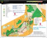
Map, trails & fences
13 September, 2015 - Greg Byrne
The final run in the 2015 IMRA nav series brought us to Joyce country (Paul Joyce that is…). The starting point was the car park of the Gap Pub. Sitting neatly between Annagh Hill and Croghan Kinsella this location offered plenty for runner’s minds prior to the maps being produced.Mid-week instructions had indicated that the long course would be 10 controls, split between the two mountains. As the hour tolled eleven we turned over the maps to find two controls on the near side of Croghan and 8 controls spread across the Annagh Hill area. I immediately decided to go for the two on Croghan. Nothing like getting a small job done quickly to boast confidence and enthusiasm. As I went up the hill past the school Adrian joined, with Seamus O’Boyle close by and the black silhouette of another runner shadowing as well. The first control (#9) came quickly and we made off up the road, spurning a more direct track due to obviously felling in the area. I had chosen a pair of trail shoes instead of fell runners in anticipation of fire roads and at this point I was happy out. As we climbed Seamus struck out in front and picked up the next control (#10) ahead of myself, Adrian and our unidentified shadow. It was now time to head back and we chose to take the fence line seeking a trail marked on the other side of a slight brow. As we descended from the brow it became obvious that the felling spotted earlier had gone all the way to the fence. I suggested we’d missed the trail and Adrian prompted a direct run for the road. I stopped to check the map… beside what turns out to be a branch off the missing trail. The lads were well on their way to the road so I headed left in the hope of getting some of the gap back, but emerging from the school I was now 50 metres ahead of Seamus. The battle was won, but the war continued and so our little road race took off towards the forest entrance to Annagh Hill.
Along the road I scanned the map and decided to avoid the steep climb up the face of Annagh Hill in favour of running along the lower fire roads to the extreme end of the course. This was done in the hope of easier climbing as I knew the face of Annagh Hill would involve hands on knees. I made great progress down the road, but started to get very confused as trail after trail appeared on my left hand side. All seemed to be big enough to take 4x4 or forestry vehicle, much too big and seemingly well established to be missing from the map? I would later learn that the mountain is used by the 4x4 clubs and many of the trials are their training ground. At the time I kept the pace up, and folded the map to allow easier reading in one hand… but I folded it right on the next junction. I was looking for a left turn. I’d lost count of the left turns I’d passed so I scanned for other details. I noticed a change in forestry and could see this above so I took the turn. Immediately I started to doubt the decision. I opened the map to see the turn I had just taken was marked with a turning circle, it was not the one I was supposed to take. Turning back was the first option, but instead I took punt of the narrow line of tall trees hoping that the older deciduous trees would offer good running below. I was in luck and a double track provided a rapid descent to the correct trial. From there it was downhill to #4 and onwards to #1 at the extreme end of the course.
From #1 it was a steep climb by the obvious wall… payback for skipping the face of Annagh Hill? The ground was good, but the muck was very loose and slippery in the rain, which was a problem in the trail shoes. Should have brought the fell shoes? Following the wall I emerged to the junction where #2 should be, but where was it? Control description said a grass path. I could see one on front of me, but no control. That said I would see five different paths… my fourth guess was the right one.
I had now gained the wall which would lead to the next two controls. #3 was described as a break in the wall. Well I can safely say there are countless breaks in this particular wall, one of which provided a detour and two more which caused some anxious interrogation of contour lines. In the end the control was obvious and #5 quickly followed. In the space between #3 and #5 the race suddenly came back alive as I passed about 10 runners, all going in the opposite direction. This included Seamus, Adrian and Brian Flannelly kitted head to toe in black (our previous shadow?). Where was John Bell? Looking at the map I estimated that we were evenly matched, but only if I got good running to the end as I knew they were descending to #1 and then on road to the finish. This spurred me on to #5.
From #5 it was a climb with the map indicating a trail to the right. Much too quickly a trail appeared, not any old trail, but the trail equivalent of a newly paved motorway. Looking up the hill I could see a bank of mist and Niamh O'Ceallaigh bouncing down the mountain. Where was she coming from? This yellow brick trial had appeared too quickly, but it was going the right, was contouring at the start and descending slightly thereafter. Right so, off we go, but the doubt lingered. Emerging from the mist I was looking towards a manicured field and the unease increased. I lost confidence and leapt off the road onto a sheep track to the left which brought me up to a higher trail, but did so at a fence that was not marked on the map. At this point I remembered Paul’s instructions that fences were not all on the map. Was he talking about this one? Ah… 30 seconds wasted I jumped the fence and descended again. Finally I reached a track corner and found control #8.
I now turned and faced a wall of heather… another steep climb. The thrill of the race drained as I thought of the lads sprinting along the roads on the other side of the hill. I trudged up the hill, where I was lucky enough to meet four other runners. The company brought back the reality of the race and I knew that from here it was downhill to the finish. I conservatively stuck to the main trails, but was glad as I don’t think I would have had the grip for more adventurous descending.
Coming into the line I was fourth, just behind John and Adrian. Seamus had finished well clear, but John and Adrian had literally met each other at the car park coming from opposite directions.
Well done to all who braved the conditions and the decisions. Deserved wins for Seamus and Niamh.
Many thanks to organisers; Paul, Mick, Derek & Co. Thanks to Mike Jordan who vouched for my ‘imaginary yellow brick motor-trail’ en-route to #8, and thanks to Mick Hanney for taking a photo of it while demarking.
Another series done; one that had everything, both in terms of style and weather. Everyone one who completed a course is a winner in these challenges. Thanks to Gavan for driving it on and giving us the chance to get properly lost in the joy of the mountains.