
Nav challenge 1 - Trooperstown
Forum Messages
| Author | Date | Message |
|---|---|---|
| Gavan Doherty | May 13 2014, 10:47pm | Hello, The annual Navigation Challenge series is back this year! The dates are at the end of August/early Sept, and as with last year we'll be having a short course (that any Leinster League runners can manage) and pre-printed maps. Long course remains the same, an epic 50k mountain challenge spread over 3 races. Now... Brian O'Meara has volunteered to plan Nav Challenge 3 (Sep 14th), and he's likely to introduce us to some unknown corners around Aughavannagh. For his troubles he gets a non-running volunteer 'credit'.... Would anyone else out there be interested in taking on the planning of another area/route? You might have an area around Dublin/Wicklow that you're keen on, or some ideas - now's your chance to share them! I'll sort out maps, printing, timing, help on the day etc. All that would be needed is: - an idea for an area that's good for a short course (mostly on trails/forest roads) - have a rough idea of how to read a map and/or GPS and get out there to check the viability on the ground - possibly help putting out checkpoints the day before If you're half interested and just want to discuss it (even if it's just an idea you have and couldn't commit to helping out), drop me a line on 086 262 1445 or gavan.doherty [at] 247meeting.com dates are on the calendar: Sun Aug 24 11:00 AM Nav challenge 1 NC Sun Aug 31 11:00 AM Nav challenge 2 NC Sun Sep 14 11:00 AM Nav challenge 3 NC If committed by July 1st Richard's promised you your non-running volunteer slot, so if that's your thing (or not), let me know. |
| Angus Tyner | May 14 2014, 10:55am | I'm unavailable for both NC 1 & 2 so can't defend title, so may as well plan NC 1 How long is short course option? |
| Gavan Doherty | May 14 2014, 11:25am | Thanks Angus, Short course should be doable for all Leinster League runners. Winner should be about 1 hour, with the last few coming in in about 2 hours. Depending on terrain (runnability & complexity) it should be max of about 10k, and stick to forest roads/recognisable hill tops & features (no tricky navigation or nasty stuff). It's very much to encourage people who are uncertain about map-reading to give it a go. I should be at the race tonight so can talk to you then. cheers, |
| BrÃan O'Meara | May 14 2014, 2:59pm | Gavan, the inference here being that all the tricky and nasty stuff should be saved for the long course? ;) |
| Gavan Doherty | May 14 2014, 4:01pm | BrÃan, You've been on enough of the Nav Challenges to know how true that is! Cheers, |
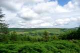
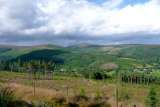
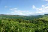
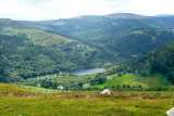
| Angus Tyner | Aug 15 2014, 10:46am | Bumping this to top. Planning has been finalised. Have added a few photos of potential views The tricky and nasty stuff on long will be route choice dependent... |
| Paul Smyth | Aug 15 2014, 10:52am | Guys, what map are we using for this? |
| Angus Tyner | Aug 15 2014, 10:58am | Maps are supplied, pre printed on waterproof paper, A4 size |
| Paul Smyth | Aug 15 2014, 11:01am | Scale? Legend? |
| Angus Tyner | Aug 15 2014, 11:04am | Eastwest map specially commissioned for this event. Scale 1:30000 same legend as eastwest. |
| Peter O'Farrell | Aug 15 2014, 12:22pm | Fair play. Ye are the Legends :) These are amazing events, with emphasis on Event. you get to see places you have never seen before, quite often places you didn't expect to be in ;) Now then, my fancy watch can tell me what altitude I am at if I ask it. Is that cheating or just help? note : I asked Paul Nolan before at a Glenmacnass NC and of course it was verboten that day so I didn't use the feature. I like it though so just clarifying again! |
| Gavan Doherty | Aug 19 2014, 11:43am | i've been away a bit, but now the NC1 page is updated with (I hope) all the details. if not, post up here & I'll get the info up! Same format as last year - Short course for novice navigators & Long course for a challenge. This Sunday's short course in Trooperstown is very short (7.8k) & a perfect introduction to navigation for anyone. It roughly follows the Trooperstown race route (yes, that's a hint). If anyone wants I'll go through the map basics once the main start has gone (eg 5-10 minutes of instruction). Specific questions: @Angela - yes you'll be back in time for tea with your mum. Short Course is effectively the Trooperstown race route (less climb), so you could take your race time and factor in a bit of time for map-reading you've got your finish time! @Peter - Garmin & any other GPS gizmos are allowed, knock yourself out! I still think if you're relying on them you're slower than a good map-reader, but I'd love to be proven wrong. The emphasis will be on picking a good route. People shouldn't get lost, the checkpoints won't be 'hidden', but how you get from one to the other will decide who wins. @Paul - maps are pre-printed and waterproof for Long and Short courses. No need for anyone to buy a map (many thanks to <a href='www.eastwestmapping.ie'>EastWest mapping</a> for their support. Any other questions, feel free to post them up. |
| Maike Jürgens | Aug 20 2014, 5:24pm | Hi Gavan, does the hint also work for the long course? to anyone who is not sure about giving the short course a go: i only learned how to navigate last year and started off by following trails on a map and designing my own routes. then i took it step by step to include more open mountain off trail stuff and it takes you to places you wouldnt get to otherwise so it is a nice skill to work on. definitely give this a go, especially if there are hints beforehand (you can familiarise yourself with the map before the day ...) |
| Gavan Doherty | Aug 22 2014, 9:41am | hi maike, no hints for the long course (bar the instruction that it crosses several busy roads!). I agreed with maike - it really adds a dimension to the hills if you can find your way around them, so if you've a half inclination to find out more about navigation the short course is a perfect start! |
| Sam Scriven | Aug 22 2014, 11:18am | hi, Hoping somebody could offer me a lift on Sunday. From Harolds Cross/D8 or any Luas stop. o87-2l36574 Thanks |
| Gavan Doherty | Aug 22 2014, 12:37pm | forgot to say that if anyone wants to start early that's fine. I'll be down there from 9:30. I'd prefer early starters to late finishers! |
| Sam Scriven | Aug 23 2014, 9:41pm | Spin sorted. Thanks. See ye in the morning! |
| Angus Tyner | Aug 23 2014, 10:28pm | Just back from putting out most of the checkpoints...with aid of head torch. Its fantastic out there, heather in bloom, weather great, you know you want to be out there with map in hand... |
| Stephen Bailie | Aug 23 2014, 11:05pm | Hi I know late notice but if anyone needs a lift in the morning give us a text now at o86 two49eight385. Heading from Lucan so can collect from anywhere |
| Alice Clancy | Aug 24 2014, 4:13pm | Thanks for a great run! It was really well organised and a nice course. Lovely to finish by dipping legs in river! |
| Maike Jürgens | Aug 24 2014, 5:39pm | race report (or ramble about ferns) written, thanks all for today. |
| John McCann | Aug 24 2014, 5:43pm | Thanks Gavin, Angus, Vivian and team for a really enjoyable day out. Roll on next week.. |
| Angus Tyner | Aug 24 2014, 5:55pm | Results also posted in report. Splits can be viewed in detail at following 2 links Winsplits http://obasen.orientering.se/winsplits/online/en/default.asp?page=classes&databaseId=32548 Splitsbrowsers http://www.splitsbrowser.org.uk/splitsgraph.php?eventId=7541 Well done all! Results will be uploaded to IMRA results database in time. I'll see if a map can be uploaded so that routes can be drawn. It would make for very interesting viewing Short 7.8k 350m Name Class Club Time 1 Brian Sugrue 60:33 2 Karl Maguire 61:16 3 Torben Dahl 61:26 4 Anthony O'Reilly 61:34 5 Siobhan Delaney 63:43 6 Hilary Jenkinson 76:32 7 Alice Clancy 76:43 8 Zoe Tyner 78:05 9 Keith Fitzsimmons 79:04 10 Vivian o'Gorman 80:03 11 Eddie Cousins 81:23 12 Jason Dowling 81:26 13 Regina Kelly 83:12 14 Thomas Galvin 86:39 15 John Greene 87:38 16 Melanie Walsh 89:49 17 Eileen Walsh 103:10 18 Anne Hodge 105:20 19 John Fitzgerald 111:17 19 Eamonn Hodge 111:17 21 Marguerite Clarke 111:20 22 Jane Walsh 113:15 23 Theresa Doyle 121:49 24 Maeve O'Grady 135:53 25 Josh Philips 148:19 26 Rory O'Loughlin 148:20 27 Conor Archer 148:21 Paul O'Grady DNF Vincent & Elle Giguere-Walsh DNF Adrian Burns DNF Long 11.2k 800m Name Class Club Time 1 Conor Short 112:50 2 Paul Mahon 117:12 3 John Bell 120:33 4 Ruari Short 121:44 5 Sam Scriven 126:01 6 Eoin Syron 137:14 7 Niamh O'Ceallaigh 138:47 8 Paul Smyth 147:49 9 Paul Keville 148:25 10 Robert O'Neill 149:14 11 Kevin O'Riordan 149:20 12 Roisin McDonnell 150:00 13 Dallas Baird 158:29 14 Denis Deasy 166:10 15 Frank Brazil 166:26 16 Ruth Lynam 167:23 17 Daniela Boehm 175:32 18 Colin Walsh 176:20 19 Alan Nicol 176:25 20 John McCann 182:51 21 B Delaney 184:42 22 Maike Jorgens 185:24 23 Stephen Bailie 187:43 24 James Cahill 199:58 25 Jarlath Hynes 203:20 26 John Condon 208:55 27 Miriam Maher 230:41 28 Karen Devenney 230:45 29 Caitlin Bent 243:26 30 Ger Power 263:35 Raghnall O'Donoghue DNF Alan Ayling DNF |
| Karen Devenney | Aug 24 2014, 5:56pm | A huge thanks to Gavan, Angus, Vivian & all involved today...I thoroughly enjoyed it! Delighted I got pervaded to do the long course & will definitely be back for more! |
| James H Cahill | Aug 24 2014, 6:18pm | Thank you Gavan, Angus, Vivian and Zoe for a great day in the hills today. Great course layout by Angus and Zoe. |
| John Greene | Aug 24 2014, 7:12pm | Thanks to Gavan and all his helpers. It was my first nav race, I recommend it to anyone thinking about trying it. |
| John Bell | Aug 24 2014, 11:39pm | Race report up. A marked up map would probably tell a better story. The Split times are very interesting seeing where you went well or not. Thanks again to Gavan and Angus. |
| James Curran | Aug 24 2014, 11:43pm | Gavin, Angus, Vivian, Zoey, My young friends Rory, Josh, Noel and Conor loved their day out. Thanks for organising a great event. James(1663) |
| Angus Tyner | Aug 25 2014, 9:16pm | I've added a lengthy planning report in the reports section. I'm still seeing if I can get map up where you can draw your routes or upload GPS tracks I've enquired if I can piggy back this event on the Irish Orienteering website |
| Donnchadh Cullinan | Aug 26 2014, 2:11pm | I had planned on trying the NAV Challenges this year but my dodgy Achilles said no - could someone post up the check point references for the long course. Might give it a go later on. Thx |
| Angus Tyner | Sep 1 2014, 4:40pm | Getting back to Nav Challenge 1 and the long course, the map and the opportunity to upload your route, either freehand or GPS is now available. http://orienteering.ie/gadget/cgi-bin/reitti.cgi?act=map&id=397&kieli= We are indebted to Fergal Buckley who put all the pieces together and added the event to the Irish Orienteering Association list. http://orienteering.ie/gadget/cgi-bin/reitti.cgi To view the course choose Long where it says Choose class/course Please make Fergal's efforts worthwhile. Its a fantastic facility, so make use of it. |
| Maike Jürgens | Sep 3 2014, 7:02pm | just added my route - great fun with all the drawing. and interesting, especially for people with less experience so you can see where you might have made a bad decision. |