
Nav 1 Ow
Authors
The whacky Bushes went bush whacking
27 August, 2019 - Graham K. Bushe
So, the time eventually arrived for me to try out the Nav challenge. From reading the various race reports I have always felt I was missing a good bit of fun and adventure, but with other coaching and driving commitments could never make them.Unfortunately, this year we didn’t have enough players to field a hurling team in Dublin and Adam is also without a soccer team. So, I used the opportunity to rope Adam into his (and also my) first navigational race. When I say his first, I mean IMRA, he has been on a couple of orienteering events with school and did well. Which is why I suggested he go in the first place - on condition that we went as a team ;) Thankfully he agreed. As it happened Kevin’s game was called off so he said he would come along too.
New laminated map bought (thanks Mick) and various markers tried… white board wiped off too easily, the permanent one left a smudge even after using Theresa’s nail varnish remover. I, courtesy of somewhere that shan’t be named (ie work) made a couple of colour photocopies in the general area around the start/finish and hoped for the best. Popped all the copies in plastic pouches along with master map in Kevin’s backpack. The new Innovate running vest (thanks IMRA) was adjusted to fit me, with two bottles filled - one for Kevin, one for Adam and my water bottle was in Adam’s bag. All interdependent. However, we each carried our own jacket, phone and food. The objective was for us all to get around and see how we would manage the navigation aspect, the racing element was not to be mentioned or even thought of (let’s see how long I could manage that!)
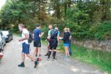
Bright and early Sunday morning Inigo rocked up to our house and we all travelled up to race start via the circuitous route (thanks Joe for the heads up on the forum about the Ironman road closures) We arrived and saw a lot of familiar friendly faces said a few hellos and got registered. Before long RD Clare was going through all the required details. She was doing it all so confidently and competently, I had no idea it was her first go, so well done! The amended map was up and details had been noted. Then the awaited moment arrived. All the sheets were handed out and when everyone was ready, they were turned over. Providing us all with a list of numbers which would ultimately decide where we would be venturing that day. Every began to carefully plot their points. I had the copies ready and used a good big black marker with no worries about smudges or wiping. Chuffed! Taking our time to get the points down the master was actually put up before we moved off. But with the group gathered tightly around it we decided to make our way out onto the course.
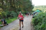
First choice was whether we would go left to control 7 or right to 1. We decided on right. All going well so far. We were delighted (well I was anyway) when we found our first control. Looking at the map, Adam decided to progress up the narrow path. Things got a bit tight and movement slowed, but we pressed on. Things got a bit tighter and a bit scratchy, but we pressed on. Things got a bit prickly and a bit stingy… but we pressed on anyway! I was really thinking about how wise it had been to take this so-called short-cut and remembered the comments that had been posted and I was also imagining all the other runners out on the main fire road sauntering happily up to their next control. I turned around only to find Andy, Sandra and someone else hot on our heels, so we… yeah, you get the idea. Eventually, we made it out of the jungle and surprisingly made it easily to control 3 (our second) Andy had reached it before us and on the way back said he’d had enough short-cuts! We gave it a bit of thought and reckoned it couldn’t be worse than the first and that the gain would be worth it. So, we found the stream and followed up to the fire road. This looped around and led towards control 5. I saw what looked like a feint line and possibly a short-cut, but we decided not to chance this one and followed the trail around. We eventually spotted the viewing platform across the valley. Things were going quite well all things considered. We had arrived at all our controls without and hassle. Adam spotted the link to the next fire road and we turned for our last one, number 2. We dropped a bit early and found ourselves down by the river again. The section looked to have young trees, so we decided to stay close to the river and look for a gap it the tops of the mature trees that would suggest a fire road. It worked and we came up exactly at the control. Absolutely perfect. Then it was just a matter of getting back to the finish.
Kevin and Adam had just about finished their water, so I divvied out mine (with a sip for myself), only then realising the time. I decided to try to push on a bit, which may have met a bit of resistance from Kevin (he had played a match the night before). And I did lapse and use the Race word. We got out onto the road and the team theme seem to take a bit of a dent. Adam dropped the hammer; Kevin dropped the anchor and I was left in the middle.
So now he has it, and official placing in the results ahead of me, well done Adam!
Will there be another Team Bushe event? Not so sure. I think I’d be dropped, lol, even though I carried the water.
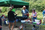
A truly great day out in the beautiful Wicklow Countryside (I know, some of you were finished when it was still morning, ha ha). Thanks to Clare and her wonderful team of helpers for making it all possible. Thanks also for the Family spot prizes and tasty nibbles.
Oh yes, Route choice….1,3,5,2.
On chatting afterwards with Inigo, who had finished an hour before us, we discovered that we had not marked #9 in the right place… meaning that 7 was not an outlier… meaning that we would have taken a different route… meaning that… we still had a great day anyway!!
OWCH
26 August, 2019 - Andrew Hanney
IMRA 2019 NAV 1 - Ow - Short courseSo I'm sitting on the beach on a lovely Sunday evening a good few hours after finising the first navigation challenge of 2019, only its far from lovely my legs and arms are on fire from the salty water......well how did that happen?
I fondly remember Aughanvannagh. Back in 1994 the 76th Scout troop from Finglas West made many a visit to the An Oige hostel (the old barracks) and we had gone on hikes up along the Ow river. Not much has changed but the hostel isn't a hostel anymore which is a great pity, as it would bring more visitors to this beautiful part of Wicklow.
Things are being done a bit differently for the Nav challenge 2019, so we're providing our own maps this year. As I was covering my own map in school book film the night before, and was congratulating myself on the good job I did, I looked a bit closer and realised I had just fantastically laminated the 1:30000 map and not the one Mick has advised.
So begins the first panic, do I go with the old version, I mean it can't have changed that much, but I re-read the forum and Mick had already answered that the new version would be the best. So I got on at the last second from Mick, literally.
Soon after Claire is handing out the paper, everybody is eyeing everyone else so there's no cheating. Like you could instantly recognise the co-ordinates or something and form a mental image of the course ahead of everyone else.
It’s time to turn the map and everyone collapses, well, kneels on the ground, plotting in the points for the short course we do any 4 out of 9. Sounds simple, but the ass kicking meted out by the Navs last year tells otherwise.
Club mate Sandra Pegman is doing the same, all of a sudden everything is plotted, I do a quick recheck and number the points. No need to check the master, what will be will be.
We eye a loop between controls 1,3,7 and 9. The only decision was which way to go, clockwise or not. Then it’s time to start running and we do, but of course I forgot to put anything away. So I'm holding my pen, compass, control sheet, and 20 other things and my trustee new inov8 bag courtesy of IMRA committee 2019 is flapping around. I stop and organize everything and start actually running again.
We decide to go anti-clockwise as it makes for a nice downhill finish needing no naviation from 7 to home. At this point you can still see other competitors heading out, of course some would be going your way and others not.
We start running uphill, and then whack, the heat, heart rate straight up, no warm up done, better reduce the pace until warmed up. On the way to control 1, I'm eyeing up the track that continues on after the control, seems like a good way to get to control 3, I remember the advice from the forum, some short cuts won't be short. But I see Graham Bushe and family up ahead, so we decide 1) others are taking the gamble 2) If it gets bad, at least they'll cut a way through the forest for us 3)Graham would never let the lads suffer that much (I was wrong).
Well it was bad, and later when I had a dip in the sea at Greystones, my whole body was on fire from the head to knee exfoliation offered by that 200 metres of gorse, stingers, spine covered branches whacking you in the face along with ankle breaking deadfall and anything else horrible you can imagine. As Alan already said, this was the OW in Ow valley. I tell Graham Bushe as I pass that he’s gonna feature heavily in my race report. But in reality it’s these gambles on shortcuts that can make a huge different in the Nav challenge, some work some won’t. A check on strava later revealed that we hadn’t proceeded long enough past control 1 but also that several other people experienced the same pain!
Eventually we break out onto the fire road, hitting control 3, deciding not to risk a quick repeat by going straight up past control 3 to reach the fire road above, at best it would save a few minutes, at worst I might have no skin left.
At this stage I'm all warmed up, so I manage to get into a run, up the hill towards control 9, overtaking a few other lads here, passing a quy who'd taken the short cut from control 3. Its only then I started to take in the beauty of the valley, with clear skies, it really opens out. Wow! You can see all the way up to Lug and beyond. I pass a runner and notice he's no water, its baking and the new bag means I've two bottles, he is happy to take it, good deed for the day check.
Usually I'd stop and take photos, not today I said, keep going. Finding the start of the zig zag that leads to control 9, I thought with the contours I'd be flying here but the ground isn't great, the trail is rocky and mostly submerged.
I can put the map away and concentrate on not breaking my face, passing another guy here.
Then its time to zone in on control 7 so I check the map, erm there's no control 7.... just a smudge of black marker when I'd written 7 at the start an hour ago, which was been wiped off by a mix of sweat, fly repellent and whatever else.
So I pull out the control sheet (which I'd held in my hand at the start), that had completely disintegrated with a mix of sweat, fly repellent and whatever else. Just as well Sandra was there with the co-ordinates and then control 7 was back on the map.
Sandra reaches control 7 at the same time she had just done the Frank Duffy 10 mile the day before so is gonna take it easy on the way to the finish, so I am going to head on.
Now I could enjoy the finish, about 3k of downhill fire road with no nav needed. I secure everything and make my way down as fast I could. Every time I rounded a bend I was saying where’s the bleeding cars that would let me know I was near the finish. Eventually after what seemed like an eternity there was the bleeding car, and the finish line shortly after, a quick look around confirms not too many people in ahead, well 3 people exactly. Happy with my 4th place. Sandra finished shortly after in 6th place.
Well done to Claire, Mick and volunteers on a wonderful course. I know a lot of work had gone into this challenge and we are all very grateful. We food at the end was amazing. There seemed to be a lot more people than usual at this NAV, I hope it continues, they are go much fun and you’re missing out on a great part of mountain running if you don’t check out the NAV challenge. Well done everyone.
Aughavanagh notes
26 August, 2019 - Mick Hanney
Reading Andrew's report I recollect my first ever time up Lug from Aughavanagh with Andrew a long time ago, hiking up on a Good Friday, it could have been 20 years ago, before either of us where halfway fit. Good times.I also remember Joe Lalor's Nav here 10 years ago in the low cloud and rain - when a small field of runners - did a loop of the valley when I distinctly remember finding some controls more by luck than skill.
Nav1 observations. We had lots of fun surveying the area and plotting the challenge. In the planning there was early consideration to bring people to potential controls on the other side of the river or towards Slieve Maan before we settled with what we have.
Short course – most people chose a combination of 1,3,7 and 9 and the main differences where whether you took it clockwise of anti-clockwise and how tangled up in gorse you got! Knowing the route very well at this stage I think I would have gone 7, 9, 1, 3 – leaving a very fast downhill finish.
Long course – Lots of route variety but majority of people seemed to drop control 5 as their outlier. Did anyone drop control 2 out of interest? For me a clockwise loop seemed to make sense, leaving out 2, favouring more track to bush-whacking. Conor’s choice of finish via road was interesting.
Some control notes:-
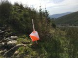
7 (stream) straightforward, just off fire road. Sorry if some people thought it slightly hidden. Always the risk in leaving kites too visible from a public track that they might be disturbed.
9 (bend) finding the start of the single track from the fire-road is initially problematic. The track itself is more a boggy stream in parts, but it is better than trying to bush-whack off it as the gorse and young forestry below and above is messy. The track entrance is straightforward if you are descending.
6 (stile) is straightforward in the clockwise direction.
4 (lake) can be tricky. The map correction of the fence was helpful given the lake wasn’t too far away. The fence was a natural hand-rail towards the next control too and today in the sunshine you could see the fence going for some distance into the horizon.
8 (memorial) is straightforward but I wonder if the hike uphill could be improved on by dropping this control? In placing and retrieving this control I found the going very slow on the heather hillside.
2 (gun tower) is very clear from the other side of the valley, not so easy to find from its nearest track, the gap in the trees is easy to miss. The ground on the other side if very messy and slow to make progress, up or down.
5 (track end) is straightforward but requires more distance to reach.
1 is straightforward to pick up. Those that tried to venture onwards up the single track shown on the map that runs into a gorse and trees-down cul-de-sac which is pretty bad. When surveying I found I had to return the way I came in.
3 (track end) is straightforward except if you come down by the brook where the trail end isn’t so obvious.
Those who crossed up or down madman's steps are madmen :-)
IMRA Nav 1 2019 Ow – or – The closest crawling through trees may come to being the best route
26 August, 2019 - Maike Jürgens
As summer comes to a close and evenings get shorter, it is time again for the annual IMRA nav challenge. My summer was injury impacted with very little running (but at least that made me do the 30 km cycle to work a couple of times to make up for it) so I wasn’t sure what would happen on a long run. But sure we got a nice day – what was the worst that could happen?Mike wanted to help out as a running volunteer so I opted for the early start. I had some gear issues with air bubbles in my water bladder in the bag and failed to fix it before the start – grand I thought, it will just have to do. After a briefing during which I couldn’t wait for the paper with the grid references (did I miss crucial information – who knows), the early starters went to plot the grid references. As expected, the special feature in the map correction was a control point. I took one look at the controls and had my first two picked – No 7 and 9. No 7 was about 2.5 km along the fireroad that I had looked at the day before as a potential outward route from the start. Off I went and about 500 ml later decided that I had to stop and fix that air bubble (note to self: do this the night before next time). About 3 minutes wasted and off I went again. Another about 500 m later and I decided I was too warm and had to remove a layer – was I ever going to get going?
Back to the map, try and focus on where you are going. Unhelpfully, I had folded the map so that I could see most of the controls but not the fireroad to no 7, so there was a lot of checking to make sure I hadn’t missed it. Found the river, saw the control, punched it and had my body calibrated to the map scale. Next up, I went to no 9 on an acute track bend. There was a little trail marked through the forest leading up to the track – unfortunately, the forest had been felled and a little bit of trail spotting was needed before I found the way up the hill. A few disturbed sheep later I was at control no 9. Decision time – would I follow the track up the hill to meet the fireroad or go up by the side of the river? Those who know me will know which way I would normally go – the direct line through the trees. A bold decision but one day it will pay off! At least I checked was it mature forest this time, as I didn’t fancy hand picking pine needles out of the mesh on my backpack again. A few fallen trees had to be climbed as well as a few nettles dealt with and I was up the hill crossing the fireroad as planned. A bit of pfaffing to get back into the forest and I went further up hill to control no 4, the pond (had the forest not been mature at this point, I would have followed the fireroad to the stile at no 6). More fallen trees and climbing but it was fun. Eventually, I ended up on open mountain, took a bearing for the pond and strolled through the heather. A few sheep tracks made life easier.
The pond was like a mini three lakes but I found the control quick enough. 3 done, over to the air crash site. It was nice enough ground but the flies were mental. I made it to the next control and took a bearing to a little trail through a firebreak in the forest. I hadn’t seen anyone in ages and was wondering when I would meet other runners. And whoops – I met John Bell powerhiking up the firebreak. Followed by Alan Ayling on the fireroad. Ok, concentrate, look out for the firebreak that will bring you to the special feature. Couldn’t wait for it and just walked through the trees (being short pays off sometimes in life!) – I did use the firebreak on the way back.
My plan for the second half included loads of fireroad to prevent me from making silly decisions of crawling through trees. So I followed the fireroad around for about 2km to get to a little trail that would bring me to control no 5. I was informed by two runners that the trail didn’t exist so I just beelined through the trees. A nice jog along the fireroad to the bridge. I am getting really hungry, thirsty and tired and slow. I didn’t eat or drink since pretty much the start and just felt really sluggish. On my way to control no 1, my second last one, I met the winner, Conor Short running towards me and was furiously trying to figure out which route he could have possibly chosen – there was soooooo many options!
A handful of gummi bears and some water gave me enough energy to get to control 3, my last one, I met Richard on the way. On the way back another runner was coming up from control no 1 and we took the same route to the finish – so I just had to keep going. A lovely welcome at the finish line, a dip in the river and some sandwiches, cake, prizes and a lot of water. Followed by a lot of discussions about all the possible route choices one could have made.
Thanks to all the volunteers for organising and anyone who is tempted should really give it a go!
Ps: the bold route choice did pay off in that I was maybe comparably faster compared to what I could have been but too little water and food on the way meant I lost all the time in the second half (maybe more training would have helped too :D )
OW!
25 August, 2019 - Alan Ayling
“Ow”1. Interjection (used especially as an as an expression of intense or sudden pain).
2. A river and its valley in south Wicklow, bounded by the ridges of Lybagh to the west and Doyle Street to the east.
Well, there were plenty of both today.
The first Nav Challenge of 2019 saw debutant Clare Keely take on the Race Director role, with the experienced Mick Hanney as Shadow. A fine job by the two and their team of helpers ensured the event was more or less flawlessly organised. The weather was kind – early mist had burned off – and the scene set for plenty of interesting route choice. The unseasonally wet August we've had made sure there would be soggy feet all around but didn't dampen the fun on the day.
There was a sense of being back in school at exam time when we were all handed a sheet of paper but not allowed turn it over until Clare said so. On it were the grid references and control descriptions. We were back to the old school way of Nav Challenges – none of your pre-marked maps now, instead find a flat bit of fire road and carefully mark the controls onto your map from the grid refs. Mostly that went well, we hear. Mostly, but not completely. There were at least 2 cases of controls marked in the wrong places on runners' maps and one of those had an impact on the top 3 in the long course.
Like last year, the format was a slightly modified “scatter” event. 9 controls, get 8 in any order of your choosing, i.e. decide which one you're going to omit. The short course used the same controls, but get any 4 of the 9. That meant all sorts of possible combinations for the short; for the long it was largely a case of clockwise or anticlockwise around a big loop and figure which of the 8 you'd skip, with 3 likely outlying candidates, or possibly the one out in the middle (#2).
Conor Short – back from Norway – set off clockwise. As did Mike Jordan, John Murray, Ivana Kolaric and by the look of things plenty of others. John Bell and I went widdershins. These things get interesting when you meet the other lot half way around and try and guess who made the better call.
In fact it came down to whose mistakes en route were the most significant. Conor got his out of the way early, overshooting the first control (#7). It was a little off to the side of the brook/fire road crossing, but not hugely so. I made my own (first) mistake early too, leaving control #1 for #3 decided on not going back around by paths and fire road, but gambling there'd be a passable way through the trees. There wasn't. Even before that, there was gorse. Lots of horrific gorse. My legs look like I've a skin condition. Ow! Then the trees, which were proper “fight” in orienteering terms, young and impenetrable, I battled eventually through a bit of space where the remains of the previous generation of forest had been dragged into a wind row – the young trees don't grow on that but the ground is dreadful, clambering over rotten sticks, branches, sometimes falling through them, sometimes falling over them. And more gorse in between. Ow, ow and ow.
Thus, Mr Bell (shamelessly clad in the now ubiquitous swimming shorts of course) had stolen a march on me. We left #1 together. I wouldn't see him again until the open mountain later on, several minutes ahead in the distance. He did manage a mistake though – a costly one. Control #6 (the stile)... John had misread the grid reference and marked it 500 m further south, at the end of the wrong fire road, right near Furry Knob on the map. He must have felt a bit of a knob himself, wandering around looking for a control that wasn't there. Fortunately he still had the sheet of paper with him, a re-check of the grid ref, a slog of 500 m and a climb of 90 m and he was back in the game.
Mike admitted to losing several minutes at one of the controls too – not sure but I think it may have been #2, the shooting hide.
Where the two route options – clockwise and counter – join for the final 700 m of joyous (NOT!) fire road to the finish, Mike appeared just ahead of John and held that lead to the line to take second place. Conor was already back some 18 minutes for the win. I dragged myself eventually into 4th eleven minutes after that, following some further misadventures along the way. I might as well recount them in case anyone is interested or can learn anything from my efforts.
#1 having gone well, but the way out of it a painful disaster, from the fire road to #3 was easy nav but draggy going. Up to the fire road above, using the open ground along the stream to the west (avoiding, for now, any more adventures in young trees) was similar – slow but not difficult nav. Apparently it was more difficult to find the control doing that section the other way around.
I opted to skip #5 (an outlier off downhill to the east), instead taking the fire road loop initially east then swinging around to NW to get #2, the shooting hide. A felled section of forest from the fire road down to the river looked easy, but it lied. It was disgusting. Lots of things to trip on, slip on, spear oneself on... ow! Across the river and up to the control site, not fast but with no issues.
The top of the clearing to the cross-slope path above was messy, so rather than play in the young trees anymore, I went for the path NW and then NE to the boots symbol, followed by the interminable drag uphill to control #8, the 1992 plane crash site on Carrawaystick. At least on the climb there were some nice fraughans to be had. It's been a rubbish year for the fraughans, but there were some juicy little beauties up there to take away the suffering of the climb.
Met Philip Brennan at the control, I remarked how rough the ground had been. “It's not much better where you're going next” was the reply. Oh great. In the event, it wasn't as bad as that at all. In fact some sheep tracks made for pleasant running most of the way to #4, the pond atop the ridge known as Doyle Street. Passed several others along there coming the opposite way, including Mike, Ivana & John M – the latter joking about visiting Carrawaystick one more time after his many Wicklow Rounds.
From #4 to #6 (the stile) should have been straightforward, but dropping to the trees too soon cost me time twice. The ground wasn't quite matching the map, I was looking for the obvious point of the open ground where the Corrigasleggaun Brook drops westward into the forest, but I was getting tired and hadn't gone far enough, wasn't judging distance well now. Twice tried to make my way downwards, thinking “this is the one”, but the forest boundary was the wrong shape, the compass said I was going south instead of west (really the only time I referred to the compass in earnest all day) and most worryingly there wasn't a bloody great brook where there should have been. Putting this information together I was able to figure out quickly enough what was wrong and correct it, but these are the kind of times when things can get really messy. I found the brook and followed it downstream to the fire road. One messy and very wet bit of ground altogether... thank you August 19 and your ridiculously heavy rains. From there to the control was handy (as long as you had it drawn in the right place ;-))
Nearly home now. Or so it felt. The second last control, #9, had other ideas. Fire road about 1.6 km SE – simples. Cross the White Stone Brook – simples. Follow it downstream and pick up the control a couple of hundred metres to the left... not so simples. The ground was steep (clearly from the map it would be), the going was horrible (not obvious from the map). Progress severely hampered by lots of fallen trees to clamber over, under or around. Lots of eye level branches intent on doing you a nasty injury. Ow! To the right, the brook, to the left, an area of impenetrable looking young trees. Well, it turned out the control was in there. Probably quite accessible from other angles (i.e. if you followed the trail the control was on), but a real bugger from where I was. Ended up too low, across the slope through the nasty stuff, then up through more of it to intercept that path. Gorse between the young trees. Ow! As a final insult, a rock comes loose as I try to scramble up to the path, have to jump out of the way as it tries to take my hand and foot with it. Ow! Pick up dropped map, go punch the control, at least there's only one to go.
Nearly missed that one (#7, the one that Conor overshot some 2 hours earlier coming the other way), but was fortunately switched on to the control description rather than just waiting to see the flag. 3 km of fire road led, at a now humble pace, to the finish.
Things got a lot better after that. There were sandwiches (very nice ones), water (much needed), cakes (yummy), tea (most welcome) and a river to have a dip and clean off a bit (delectable). Not to mention the chats and banter and war stories that inevitably follow these races.
If you're still reading, fair play to ya. A rambling report but that at least reflects how the course felt. It was a long tough one. But enjoyable. Thanks again Clare, Mick & team. Well done Conor and Ivan on their wins, as well as Linda and Chris on the short course. Can't wait for next one now!