
Nav Challenge 3 West Dublin Hills
- Description:
- Third race of annual nav challenge league
- County:
- Wicklow
- Date:
- Sunday 11th September, 2016
- Time:
- 10:30
- Climb (m):
- 600
- Distance (km):
- 17.00
- Event Difficulty:
- 8 (2,3,3) - Moderate Terrain, >500M ascent, >10Km
- Race Marking:
-
 -
Only major junctions marked
-
Only major junctions marked - GPS Allowed:
- Yes
- Leagues:
- Navigational Challenge
- Getting There:
Directions:
From M50, take the Firhouse exit (Junction 12) and proceed along the R113 through a number of roundabouts until the junction with the R114. Turn left and proceed along the R114 past the Bohernabreena Reservoir and continue up to the junction of the R114 and the Stone Cross Road (O 075 228). Turn Left onto the Stone Cross road (Shankill Road) and proceed to the start line approximately 2km up the stone cross road. The race start is at the entrance to Seehan Forest (O 076 208).
Start line Grid Ref: O 076 208
There is no dedicated parking for this race. Parking is along the Stone Cross road. There are a number of places to pull in but carpooling is strongly advised. Please carpool from Aherns pub in Old Bawn where there is plenty of parking.
In line with the new race registration guidelines, race vouchers or on-line pre-registration ONLY. Online registration and payment will close at 6pm on Saturday 10th September.
All competitors, and particularly those who have not competed this year already, should READ the NEW REGISTRATION GUIDELINES. We are NO longer accepting MONEY at races. ANNUAL REGISTRATION MUST BE COMPLETED ONLINE BEFORE THE RACE TO GET A RACE NUMBER AND BE ALLOWED TO PARTICIPATE
- Organisers Instructions:
Registration will open at 9:15 and will close at 10:15. There will be an early start (long course only) at 09:45.
Mandatory Kit: running jacket, whistle, compass and mobile phone. We also recommend a hat, some high energy food and water. If you are new to the Nav races/orienteering or learning to navigate you are most welcome to come along but consider strongly doing the short course.
Controls:
Long course: 14 Controls (Minimum approximate distance 17km with 600m+ ascent)
Short course 8 Controls (Minimum approximate distance 8km with 350m+ ascent)
All controls are marked with OT flags and punches.
Course:
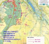
A map will be supplied at the start line (EastWest Mapping) and controls for both the long and short courses will be marked on them. There are 15 Controls in all. For the LONG course you must visit ALL 14 controls and for the SHORT course you must visit 8 of your choice. You can visit the controls in any order you choose and punch your card at each control.
This is a challenging course over a variety of terrain and includes: forest track, fire road, grass track, open mountain, heather, bog, ferns and the odd peat hag! If visibility is restricted (which it regularly is!) you will NEED to be familiar with how to use a map and compass especially for the Long course.
There is a long fence that divides the course which will be marked on the map with cross points indicated on the map. Please use the cross points/styles/gates to cross this fence. The fence is important to the farmers who graze these hills so please respect crossing it! There will also be a small area marked out of bounds on the map that is private land and we would ask you not to enter it.
- Prizegiving Location:
- At finish line
Volunteers (Non-Running)
You need to have done 2 non-running volunteer roles in a calendar year to qualify for end of year prize
Volunteers (Running)
Check with race director if they have a need for people volunteering and running. Race directors need a minimum number of people available throughout the race to make the race work so non-running volunteers are preferable. While it can be helpful, volunteering in a volunteer and race capacity does not count towards qualifying for end of year prize